Image not available
Other industries
Multispectral GP Satellite Manufacturers China High Precision Imaging Factory Suppliers
Looking for reliable China suppliers? Our factory provides GP series satellites featuring 5m resolution, multi-optical path imagers, and SWIR MWIR LWIR infrared loads for ultra-high speed broadband multispectral imaging.
SupplierAstralink Science and Technology Co., Ltd.www.space-navi.com
Source categories
About this product
Product information from the supplier.
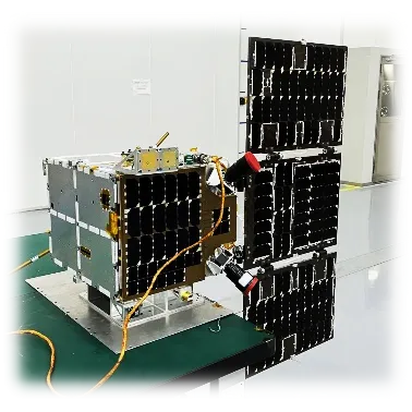
The Multispectral GP Satellite series represents a pinnacle in aerospace imaging technology, engineered for high-precision Earth observation and strategic intelligence. With a specialized resolution of 5m for near-infrared visible light, these satellites are equipped with advanced imagers supporting multiple optical paths, ensuring unmatched clarity and detail across a broad spectral range.
Designed for versatility, the GP series integrates short-wave, medium-wave, and long-wave infrared cameras, enabling comprehensive multispectral analysis. Featuring ultra-high-speed data transmission and a wide swath width, these satellites provide critical geospatial intelligence for environmental monitoring, urban planning, and security operations with exceptional reliability.
Detailed Parameters
| Satellite Model | Jilin-1 GP Series | Total Weight | Approx. 200kg |
|---|---|---|---|
| Imaging Mode | Push-broom, Night-time, Inertial Space | Swath Width | 110km (at Nadir) |
| Visible Resolution | 5m (Near-infrared) | SWIR Resolution | 100m |
| MWIR Resolution | 100m | LWIR Resolution | 150m |
| Spectral Coverage | B0-B19, SW1-SW4, MW, LW | Transmission | Ultra-high speed broadband |
Key Advantages
Multispectral Range
Comprehensive coverage from 450nm visible light to 13500nm long-wave infrared for diverse analysis.
Night-time Imaging
Advanced infrared capabilities allow for high-quality data acquisition regardless of lighting conditions.
High Resolution
5m resolution in the near-infrared spectrum delivers precision imaging for critical target identification.
Broadband Transmission
Equipped with ultra-high-speed transmission systems to ensure rapid delivery of massive data sets.
Wide Swath Coverage
A 110km swath width enables large-scale area monitoring in fewer orbits, increasing efficiency.
Inertial Imaging
Supports inertial space imaging modes for flexible and dynamic observation requirements.
Product Gallery
Management Platforms
Orbit Control
Precise trajectory management and orbital adjustment for optimal imaging angles.
Spectrum Calibration
Real-time calibration of multispectral sensors to ensure radiometric accuracy.
Data Downlink
Automated scheduling of high-speed data transmission to ground stations.
Thermal Monitoring
Constant tracking of on-board instrument temperatures for longevity and stability.
Payload Management
Dynamic control of infrared and visible light sensors based on mission needs.
Image Processing
Integrated ground software for rapid conversion of raw data into actionable intelligence.
Investment Return Comparison
| Performance Metric | Standard Satellites | Multispectral GP |
|---|---|---|
| Spectral Breadth | Narrow-band | Ultra-broadband |
| Imaging Versatility | Visible Only | Visible + SWIR + MWIR + LWIR |
| Data Throughput | Standard Speed | Ultra-high Speed |
| Operational Time | Daylight Only | 24/7 (Day & Night) |
| Intelligence Value | Low-Medium | Critical High-Value |
Frequently Asked Questions
Q: What are the primary applications of the Multispectral GP Satellite?
It is primarily used for high-precision Earth observation, environmental monitoring, disaster response, and strategic security due to its multispectral imaging capabilities.
Q: How does the night-time imaging mode work?
The satellite utilizes short-wave, medium-wave, and long-wave infrared cameras to detect thermal radiation, allowing it to capture clear images without sunlight.
Q: What is the significance of the 5m resolution in visible light?
A 5m resolution provides a high level of detail, enabling the identification of large structures, vehicle movements, and precise land-use changes.
Q: What makes the GP series different from standard optical satellites?
Unlike standard optical satellites, the GP series offers a much wider spectral coverage (B0-B19) and integrated infrared loads for all-weather imaging.
Q: Can the satellite handle large-scale area mapping?
Yes, with a swath width of 110km at Nadir, the GP series is highly efficient for regional mapping and wide-area surveillance.
Q: How is the data transmitted from the satellite to the ground?
The satellite uses ultra-high-speed transmission systems and broadband communication to move massive multispectral data files rapidly.
Ready to Elevate Your Aerospace Intelligence?
Contact UsMore from this supplier
Astralink Science and Technology Co., Ltd.