Image not available

Other industries
Jilin1 GF03C 1m Resolution Video Satellite China Suppliers and Factory
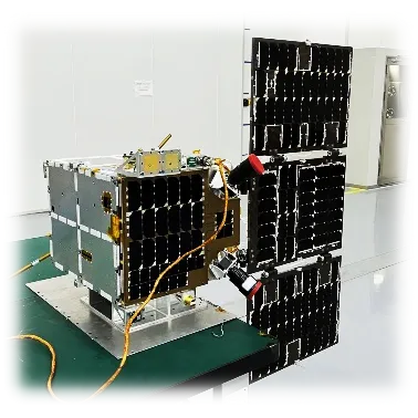
Looking for high-performance remote sensing? Jilin-1 GF03C satellites are video series optical remote sensing satellites with 1m resolution from leading China suppliers. Our factory provides low-cost, low-power, and lightweight array video imaging solutions for global aerospace missions.
SupplierAstralink Science and Technology Co., Ltd.www.space-navi.com
Source categories
About this product
Product information from the supplier.
The Jilin-1 GF03C represents a breakthrough in optical remote sensing technology, specifically engineered for high-precision video imaging from space. As a specialized video series satellite, it delivers an impressive 1m resolution, enabling stakeholders to capture dynamic terrestrial events with unprecedented clarity and temporal accuracy.
Designed for maximum operational efficiency, the GF03C optimizes the balance between performance and resource consumption. By integrating low-cost architecture with low-power and lightweight design, it provides a scalable and sustainable solution for array video imaging, making high-resolution satellite surveillance more accessible for diverse aerospace missions.
Detailed Parameters
| Satellite Model | Jilin-1 GF03C | Imaging Mode | Video Imaging |
|---|---|---|---|
| Ground Resolution | 1 meter | Spectral Coverage | RGB (Multi-spectral) |
| Blue Band | 437-512nm | Green Band | 489-585nm |
| Red Band | 580-723nm | Swath Width (Nadir) | 14.4km 6km |
| Total Weight | ≈ 40kg | System Feature | Array Video Imaging |
Key Advantages
High Resolution
Delivers a precise 1m resolution, ensuring sharp details and high-fidelity video capture for critical remote sensing tasks.
Energy Efficient
Low power consumption architecture extends operational longevity and reduces reliance on heavy power systems.
Cost-Effective
Optimized manufacturing and design significantly lower the cost per image/video compared to traditional satellites.
Dynamic Imaging
Specialized array video imaging capability allows for the monitoring of moving targets and changing environments.
Lightweight Build
At approximately 40kg, the compact weight reduces launch costs and improves deployment flexibility.
Full RGB Spectrum
Comprehensive spectral coverage (Blue, Green, Red) ensures natural color reproduction and precise visual analysis.
Product Gallery
Management Platforms
Satellite Fleet Control
Unified interface for managing multiple GF03C units and coordinating array imaging schedules.
Power Optimization
Real-time monitoring of the low-power consumption systems to maximize satellite lifespan.
Data Transmission Hub
High-speed downlink management for processing 1m resolution video streams in real-time.
Orbital Tracking
Precise trajectory and nadir alignment tools to ensure maximum swath width coverage.
Spectral Analysis Tool
Software suite for filtering and analyzing RGB spectral bands for environmental intelligence.
Resource Allocation
Dynamic allocation of imaging tasks to optimize the weight-to-performance ratio of the constellation.
Investment Return Comparison
| Metric | Traditional Satellites | Jilin-1 GF03C |
|---|---|---|
| Launch Cost | Extremely High | Significantly Reduced |
| Power Overhead | High Energy Demand | Ultra-Low Consumption |
| Deployment Speed | Slow / Complex | Rapid Deployment |
| Imaging Capability | Static / High-Res | Dynamic Video / 1m Res |
| Weight Efficiency | Heavy Infrastructure | Optimized (≈ 40kg) |
Frequently Asked Questions
Q: What makes the Jilin-1 GF03C different from standard imaging satellites?
Unlike standard satellites that capture still images, the GF03C is a video series optical remote sensing satellite, allowing for array video imaging to capture moving targets and temporal changes.
Q: How does the 1m resolution benefit aerospace and defense applications?
A 1m resolution provides the ability to distinguish large objects and infrastructure with high precision, critical for surveillance, disaster management, and strategic planning.
Q: Is the GF03C suitable for commercial constellations?
Yes, its low cost, low weight, and low power consumption make it an ideal candidate for commercial satellite constellations where scalability and ROI are key.
Q: What is the spectral coverage of the Jilin-1 GF03C?
It covers the full RGB spectrum: Blue (437-512nm), Green (489-585nm), and Red (580-723nm), ensuring accurate color representation of the Earth's surface.
Q: What is the swath width of the GF03C at Nadir?
The swath width at Nadir is 14.4km 6km, providing a substantial area of coverage for each video pass.
Q: How does the lightweight design affect launch flexibility?
With a weight of approximately 40kg, the GF03C can be launched as a secondary payload or in large batches, drastically reducing launch costs per unit.
Ready to Enhance Your Satellite Surveillance Capabilities?
Contact UsMore from this supplier
Astralink Science and Technology Co., Ltd.