Image not available

Other industries
GF Series 0.5m Resolution Satellites China Suppliers and Factory
Looking for professional China suppliers and a leading factory for GF series satellites? Our 0.5m resolution satellites feature independent on-satellite mission planning, real-time data transmission, and advanced on-satellite AI for precise Earth observation.
SupplierAstralink Science and Technology Co., Ltd.www.space-navi.com
Source categories
About this product
Product information from the supplier.
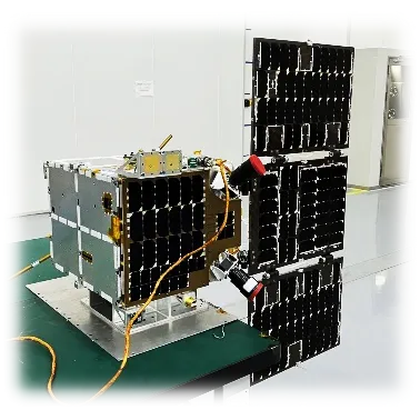
The GF Series Satellites represent the pinnacle of aerospace engineering, specifically designed for high-precision Earth observation with a remarkable 0.5m resolution. By integrating independent on-satellite mission planning and advanced on-satellite AI, these satellites transition from passive sensors to intelligent orbital assets capable of real-time data processing and rapid transmission.
Engineered for versatility and speed, the GF series utilizes fast maneuvering control to achieve single-orbit multi-point target imaging. This capability, combined with a wide 15km swath width and high-integration architecture, ensures that critical geospatial intelligence is captured and returned with unprecedented efficiency and clarity.
Detailed Parameters
| Product Model | Jilin-1GF 04A | Imaging Mode | Push-broom imaging |
|---|---|---|---|
| Resolution | Full color: 0.5m | Swath Width | 15km (at Nadir) |
| Panchromatic Color | 450nm ~ 700nm | Blue Spectrum | 450nm ~ 510nm |
| Green Spectrum | 510nm ~ 580nm | Red Spectrum | 630nm ~ 690nm |
| Near-infrared | 770nm ~ 895nm | Satellite Weight | ≈ 90kg |
Key Advantages
0.5m Ultra-High Res
Delivers exceptional image clarity and detail, allowing for precise identification of ground targets and infrastructure.
Real-Time Transmission
Equipped with high-speed data links to ensure that critical intelligence reaches the end-user without delay.
On-Satellite AI
Integrated AI capabilities enable autonomous target recognition and efficient data filtering directly in orbit.
Push-Broom Imaging
Advanced scanning technology ensures consistent image quality across a 15km breadth for large-scale monitoring.
Fast Maneuvering
Rapid control systems allow for multi-point target imaging within a single orbit, maximizing efficiency.
High Integration
A compact 90kg design that balances high performance with launch efficiency and reduced cost.
Product Gallery
Management Platforms
Mission Planning
Autonomous on-satellite planning for optimized target acquisition and scheduling.
Maneuver Control
Precision orbital adjustment system for rapid multi-point imaging execution.
Data Return Sys
Optimized downlink protocols for fast and secure information return to ground stations.
AI Analysis Hub
On-board AI processing for real-time feature extraction and event detection.
Spectral Manager
Advanced control of Panchromatic and Multispectral bands for specific environmental analysis.
Telemetry Monitor
Real-time health and status monitoring of the 90kg satellite platform.
Investment Return Comparison
| Feature Metric | Standard Satellites | GF Series Satellites |
|---|---|---|
| Resolution | 1m - 2m | 0.5m Ultra-High |
| Imaging Speed | Single Target/Orbit | Multi-point/Orbit |
| Data Processing | Ground-based only | On-satellite AI |
| Transmission | Scheduled Batch | Real-time Stream |
| Deployment Cost | High (Heavy Mass) | Optimized (≈90kg) |
Frequently Asked Questions
Q: What is the primary application of GF series satellites?
They are primarily used for high-resolution Earth observation, intelligence gathering, and environmental monitoring, providing critical 0.5m resolution imagery for precise analysis.
Q: How does on-satellite AI improve efficiency?
On-satellite AI allows the satellite to process data in orbit, identifying relevant targets and filtering out useless data (like cloud cover) before transmission, saving bandwidth and time.
Q: What spectral bands are covered by the Jilin-1GF 04A?
It covers Panchromatic (450-700nm), Blue (450-510nm), Green (510-580nm), Red (630-690nm), and Near-infrared (770-895nm) bands.
Q: What is push-broom imaging?
Push-broom imaging is a scanning technique where a linear array of detectors captures a strip of the Earth's surface as the satellite moves, resulting in high-resolution static images.
Q: Can the GF series handle multiple targets in one orbit?
Yes, thanks to its fast maneuvering control, the GF series can capture images of multiple distinct targets within a single orbital pass.
Q: What is the significance of the 15km swath width?
A 15km swath width allows the satellite to cover a significant area of the ground per pass while maintaining a high 0.5m resolution, balancing coverage and detail.
Ready to Elevate Your Orbital Intelligence?
Contact UsMore from this supplier
Astralink Science and Technology Co., Ltd.